 |
| Klein Namutoni, gem of a water hole that is easy to miss. |
Namutoni, the first camp we visited, is probably the best for game driving as the waterholes around the campsite are relatively close to each other and offer decent shooting. It also has access to the mighty Etosha pan and a few different areas for game viewing.
 |
| The Pan viewpoint, don't miss it near Halali. |
The waterhole at the campsite is not the best as its overgrown and awkwardly located but the game viewing areas around the camp make up for the waterhole.
 |
| Where did you go? |
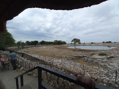
The best shooting location is Klein Namutoni located on the way back to the main gate and also home to a resident leopard.
 |
| Halali water hole offers great views of drinking animals. |
Halali is located in the center of the park and checking out the 'Pan View Point' on the way in as its one of the few places to get a really good feel of the might of nothingness which is the Etosha pan.
 |
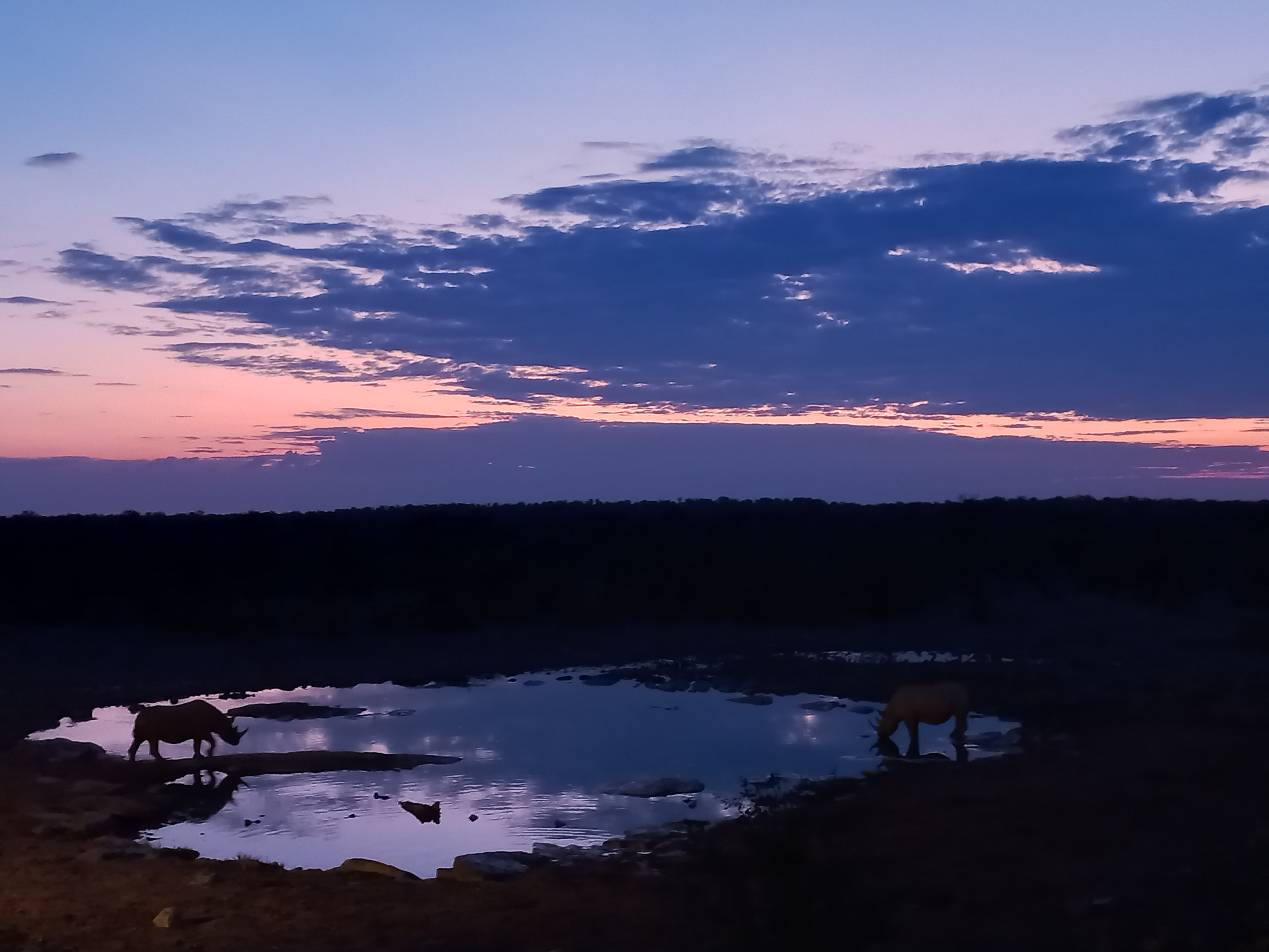
| Rhino are regulars at the Halali waterhole. |
Driving around Halali is limited and don't waste your time but head straight to the Goas waterhole which is a great double waterhole for shooting. The waterhole at the camp is also great with daily rhino sightings at night.
If you cannot find camping in Etosha, Halali is the place to head for as it has a massive campsite with plenty of space but if you get this wrong, its a 75 KM drive to get out.
 |
| The most famous tree in Etosha, the Salvadore tree. |
Okaukuejo is by far the most popular and crowded camp in Etosha due its close proximity to the Namibian capital Windhoek. The waterhole here is nothing short of sensational due to its positioning and game activity and no surprises it has a 24 hour camera featuring on live safari shows.
.jpg) |
Etosha!
|
There is non-stop parade of animals that drink here and the viewing points offer a decent angle and close proximity for shooting. Nightly rhino sightings are common but there have been sightings of all major game including lion at this waterhole.
 |
| The Okaukuejo waterhole, surely one of the best in the world. |
Around Okaukuejo, the popular drive is between Gemsbokvlaakte and Ombika waterhole at the Anderson Gate. This is also where we came across a large pride of lions and there were reports of a cheetah around the area.
 |
| Ring side view of the waterhole, walking distance from the campsite. |
Having visited Etosha in the wet, we will definitely be back in the dry season when we expect the water holes to be even more active. Etosha is a park like no other but the closest we can draw similarity to is Kalahari in Botswana with much of the same animals and vegetation.
 |
The incredible Sociable weaver nest.
|
Like the Kalahari, the main theory is target game around the waterholes and park authorities are doing a great job with both the roads and maintaining watering points for the animals.
 |
| Rhinos at the waterhole at Okaukuejo |
By far the unique feature of Etosha is the massive featureless pan itself. Once again one could draw similarities to the Makgadikgadi pans of Botswana and we are glad to have covered both on this one trip and drawing on different experiences from both.
 |
Ground squirrel, camp site friends.
|
We had a major panic on our way out of Etosha where the car came to an abrupt stop in the middle of no where but suffice to say, the guys at Outjo from Wiemanns Garage sorted us out and had us on the road the next day.
 |
Thanks Conrad for sorting us out!
|
Another breakdown on an African road negotiated, this time a faulty fuel gauge resulting in running of out fuel! We were grateful to have got out of yet another car mishap without too many dramas as once of the fears of traveling alone is a car breakdown in the wrong place, of which there are many in Africa.
As we ended our 60 day trip there were reports of a missing couple self driving, ironically just around the area we were heading in to but had decided to turn back as opposed to venturing in to remote areas alone.
 |
| The Hoab river, Twyfelfontein, don't mess around here alone! |
Twyfelfontein came in to the picture when researching the desert elephants of Namibia. This area seemed to be one of the areas to target but one had to venture deeper in to the desert to target the desert lions.
 |
| Endless vistas in Namibia |
Intel gathered from fellow travelers coming up (always talk to other travels to obtain up to date intel) from this area had warning signs of bad roads (which was expected) but total isolation, which is scary for solo travelers in a remote hostile environments. Once the tarmac ended at Khorixas, we were reluctant adventures beyond Twyfelfontein.
 |
Lots of dry riverbed driving looking for the desert elephants
|
We were on our way to the world heritage site at Twyfelfontein when we saw a sign for desert elephant drives. The guide there noted that he sighted a herd of 16 that morning which was a hot lead as the elephants were unlikely to have moved far during the heat of the day.
 |
| Making a living in the desert. |
We left them debating on a toss between the desert elephants and world heritage sight consisting of cave drawings and decided to give the desert elephants a go. The drive starts at 2 PM which was a bit strange for us but given we were the outsiders, we paid the fees and buckled up a wild ride through the Huab River in search of the desert elephants.
 |
| Inhospitable wild terrain. |
While you can do the drive to search for desert elephants on your own, and the chances of finding the elephants are good if they are in the area as they go up and down the river checking out the different watering points, we decided not to test our suspension and enjoy the ride.
 |
| The unique Welwitschia plant can survive for hundreds of years. |
While there were elephant droppings the moment we got to the dry river bed, it took us almost two hours driving upstream to find the elephants. What's more, the sand is soft and dry and will test your suspension and driving skills but most of all, if you were to get stuck, there is little or no help around so best not mess around here alone.
 |
| Petrified tree trunks. |
Sadly the Hoab river which usually flows annually, failed to flow for 7 years up to 2022 when it last flowed. But the 7 years dry had a significant impact on the wildlife resulting in the translocation of the lion population who took to feeding on the livestock in desperation.
 |
Welwitschia fruit
|
The villages took a terrible hit on their livestock requiring government intervention to restock village livestock. The hope is with the return of the rains the lions will return once again but the rains have failed again in 2023 and the villages hang on by a thread in this barren corner of the world, somehow sharing the precious remaining water with the desert elephants.
 |
| Khorixas, a place like no other but plan to arrive late afternoon. |
While it was possible to cross from Khorixas to Uis and use other back roads to reach Spitzkoppe, we decided to camp at Hais Ra and back track to Outjo and then use the main tarmac to Spitzkoppe.
 |
A lone tree makes a stand in desert.
|
While this was longer distance, we still reached Spitzkoppe the same day well before sunset and believe it was actually quicker than taking a chance on the gravel tracks.
 |
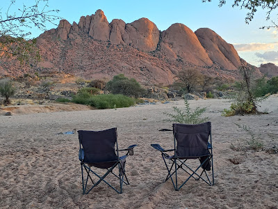
| Spitzkoppe, another of Namibia's place like no other |
Spitzkoppe itself is a weird rock formation jutting out from its flat surrounds. By this time the Namibian vegetation has taken a dramatic change to sparse and desert like flats with deep horizons. So to see anything jut out is eye catching and Spitzkoppe would be a worthwhile sight on its own.
 |
| The Spitzkoppe window |
The day time heat by now is a real challenge to deal with requiring early movements after camping overnight. Again we had the choice to head to Hentiesbaai on the gravel track but opted to get back on the main road and head to Swakopmund on the main road.
 |
Camping outside the reserve offers the best views in the mornings.
|
The first thing to note about Swakop is the sea mist which hangs like a strange ghost off the coast and rolls in unannounced without a warning bringing a chill factor that cannot be ignored. So there we arrived in Swakop in shorts and t-shirts after Spitzkoppe desperately looking for warm clothes at midday in a confused state.
 |
| Sand campsite, slippers or shoes? |
Swakop is an interesting town full peculiarities such as salt roads, European like beach fronts, dune fields, sea mist, moonscapes, strange Welwitschia plants and a strong German culture and presence. It is the second largest city in Namibia so if you are not going to Windhoek like us, this the next best place to get anything sorted out.
 |
Alte Brucke in Swakopmund
|
The best place to camp is Alte Bruche which one could use as the blueprint for the perfect campsite, albeit looking a bit artificial in the middle of town. We headed for Walvis Bay to climb the famous dune 7 only to be told the dune was closed due to vandalism.
 |
| The road between Swakop & Walvis divides dune and sea |
Never understand the logic of vandalizing public property but on dune 7! The bonus was flamingos with dunes in the background and the awesome drive between the two twin cities just 70 KMS apart.
 |
The infamous sea mist rolls in Swakop, it really is like nothing else.
|
There is a story that upon independence, South Africa were reluctant to handover Walvis Bay which was the main harbor but regardless the drive is breathtaking and hair-raising saddled between the sea and sand dunes.
 |
| Plenty of seals at the Cape Cross colony |
The Cape Cross seal colony is located 130 KMH north past Hentiesbaai which is a decent lunch stop on the way back. Get to the seals early so you don't get caught out by the weather and also the seals are on shore overnight and only venture out with sunlight so best to get there early and take they only open the gate at 9AM so don't rush off a 6AM!
 |
| Relaxing after a day of fishing |
There are seals all along this coast as far down as Cape Town but Cape Cross is special by the huge numbers and close beach access. It is called Cape Cross due to the cross placed on the ground up on the arrival of the first Europeans on this wild coast.
 |
Cape Cross, guarded by the Seal colony.
|
The next day, we checked out the Living Desert Tour which is a must do from Swakop. It starts early morning and there are a few tour operators but we used 'living desert tours' who were awesome.
 |
| The Side-Winder snake disappearing in to the sand. |
It's hard to imagine how an eco-system could survive in the Namib desert but there is water, plants and animals who live of each other ensuring an entire eco-system is busy at work but you will only notice it, if you go in with an expert who knows what to look for. What ever you do, don't just hammer around the dunes looked for stuff and the most likely outcome is the destruction of this fragile eco-system.
 |
| The world's only lizard with 4 webbed feet lives in the Namib desert! |
The toughest part of the drive lay ahead from Swakop to Sossusvlei which is a 400 KM drive through the Namib with absolutely nothing. The Namibian gravel roads require some caution and adjustment per the condition of the road so don't bite off huge chunks of distances to cover in a day.
 |
The moving sand dunes of the Namib.
|
Also don't fall in to the trap of speeding along on a smooth gravel road only to hit a rough patch and losing control. The Namibian gravel roads are deceptive for those of us from outside and require caution to negotiate.
 |
| The Moonscape of Swakop. |
Dropping tyre pressure is a must we are told and the few times we did this, there was a marked difference in handling and suspension stress. However, you obviously need a trye inflation kit with you as driving on a tarmac with deflated tyres is one sure way to shred the sidewall.
 |
| Solitaire, the one horse town between Swakop and Sossusvlei. |
There is a fair amount of fuss made about the one horse town of Solitaire, the only stop between Swakop and Soss but it's more to do with the relief of finding a human being and basic supplies than anything close to an attraction.
 |
Dune 45, the sandstorm was that strong, folks climbing had to get down.
|
There is also a lot of noise made about the apple pie of Solitaire but Dru didn't find anything special about a pie made from tinned apples (Cheryl thought it was good)! What it is a good stopping point given Sesriem (the entry to Soss) has even less to excite you except for a much needed tarmac road providing some relief from the corrugated gravel.
 |
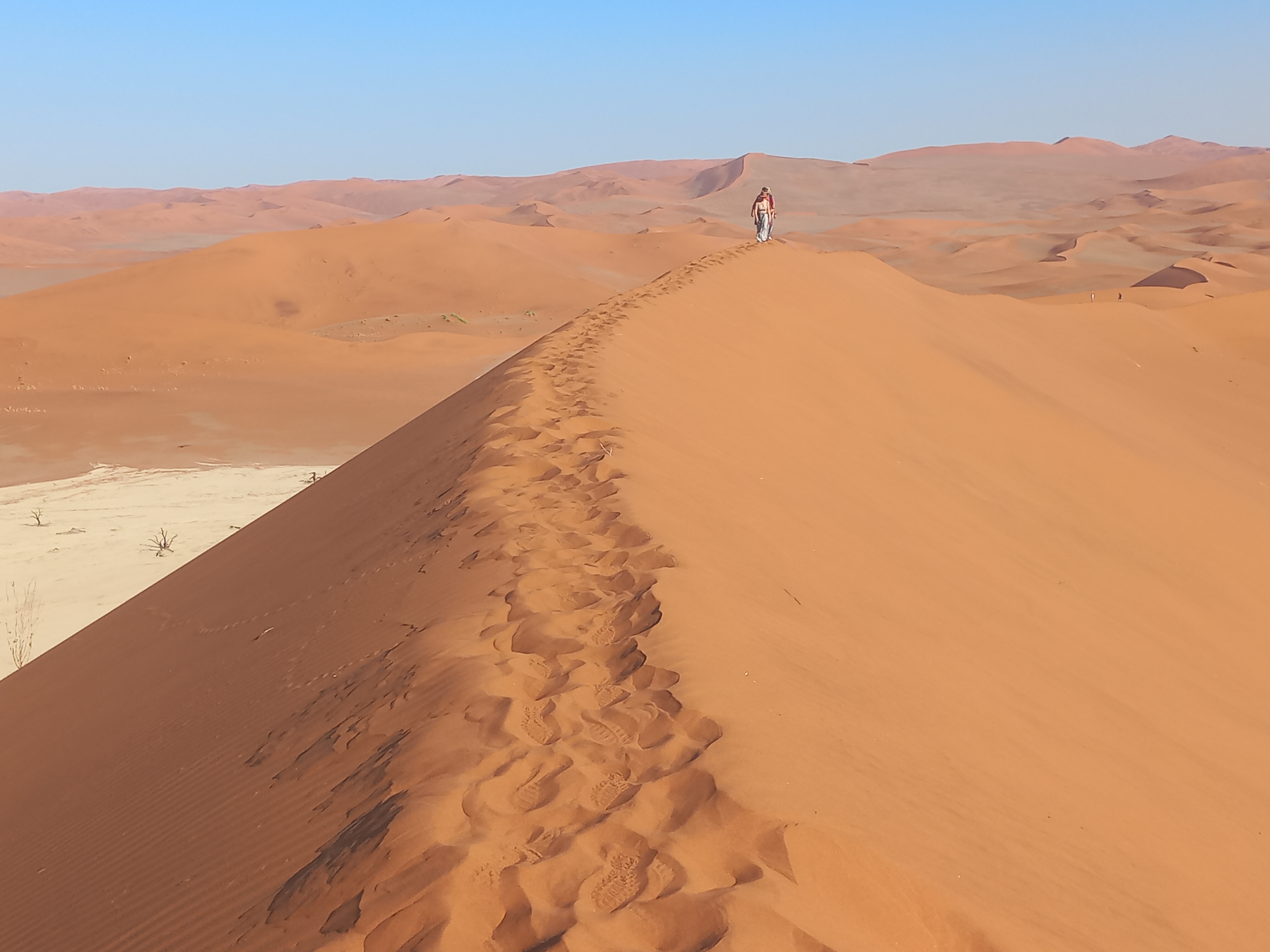
| Footprints on the Sossusvlei sand dunes. |
As it has been noted with Namibian National Parks, one needs to take note of park gate opening and closing times and where your accommodation is located (i.e. inside or outside the gate).
 |
| Individual dunes take their own shape in the Sossusvlei dune fields. |
From what we gather, if your accommodation is inside the gate, you get an extra hour of sunlight (both at sunset and sunrise) to enjoy while those staying outside the gate need to get out!
 |
| Sunset paints two sides of the dune in different shades. |
If you camping in the NWR (Namibian Wildlife Resorts) facilities, they are always inside the gate. We also found the NWR facilities in excellent order with hot water and flush in shared toilets while there was power and water at your campsite.
 |
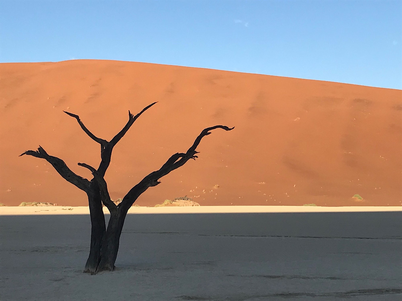
| Deadvlei, the ancient lake cut off by sand dunes. |
Soss is like no other place on earth and the star of the show is Deadvlei which you must work with to get those special images. The classic image of the dark trees against the golden sand dune requires you to be there for sunrise and that's where the accommodation location inside or outside the gate comes in to play.
 |
Trees a thousand years old, still standing.
|
It appears if you stay in certain lodges, you can bypass the gate and get on the dunes ahead of sunrise but these are for guided tours we presume. Deadvlei itself is almost like a prehistoric Jurassic like attraction and get in before the run gets to you as there is no shade obviously.
 |
| Dune climbing is not as easy as it looks and get in early morning. |
There are other dunes, some of which can be climbed which was surprising given the fragility of the eco-system. Don't make the mistake we made of trying to climb Big Daddy in the heat of the morning (after spending the early hours on Deadvlei floor).
 |
Get to Deadvlei before sunrise
|
The climb of Big Daddy is far from a walk in the park and carry plenty of water and go barefooted! We understood dune 45 is an easier climb but the most important thing around here is weather.
 |
| Big Daddy, the largest dune in Soss. |
Others told us how they had to scamper down the dunes and abandon Sossusvlei altogether due to sandstorms! Not sure how these work but we negotiated a few sand storms through Namibia and they are not to be messed around as visibility can be a challenge as is handling a moving car so standing around outside let alone on a dune is simply not an option.
 |
| Big Daddy guards one side of Deadvlei |
Sossusvlei to Luderitz is another bone crunching 500 KM cross of the Namib with a few different options all on gravel. We blew a trye 10 minutes after leaving Soss and thus needed to hit the nearest big town to get a new tyre and thus ended up spending a night to reach Luderitz using as less gravel as possible.
 |
Ancient trees and new dunes.
|
We are told it doable in a day on gravel but being cautious solo travelers, we settled for the safer and longer route on tarmac. Camping options are available and can be as diverse as a nice secluded campsite next to a river in Maltahohe to camping behind the Engen Fuel Stop in Keetmanshoop.
 |
| The peculiar Quiver tree thrives in these parts. |
While camping is possible at Luderitz, all indications are that the wind factor could be a significant deterrent and hence we settled for Aus but there are only two camp sites here so get on to those bookings as opposed to just rocking up like us.
 |
| Our very compact camping spot in Aus - go for the "luxury" option |
Luderitz has a fishing harbor and hence is well serviced and lies about 10KM from Kolmanskop which is where the main attraction, the ghost village is located.
 |
Kolmanskop is a another uniquely Namibia attraction.
|
This is an old mining town that is been slowly swallowed up by the shifting desert sands. It is worth a visit as is the Portuguese fish restuarant in Luderitz, their Fish Potjie is winner.
 |
| The ghost town of Kolmanskop near Luderitz |
The importance of chatting to fellow travelers was highlighted in a brief chat when the guys coming north firstly pointed out the correct viewing point for the Fish River Canyon and then made us aware of the route.
We were originally planning to head down to Rosh Pinah and enter South Africa through Oranjemund mainly as a result of being tired of dealing with the gravel roads.
 |
Sand up to the door frames in some rooms.
|
However, folks traveling up indicated that the road to Hobas and Ais Ais was in excellent condition with Hobas being the best view point for the canyon. This being a rushed last minute trip, we hadn't done the adequate research including a single booking and thus were not fully aware of all our moves.
 |
| An old abandoned railway station. |
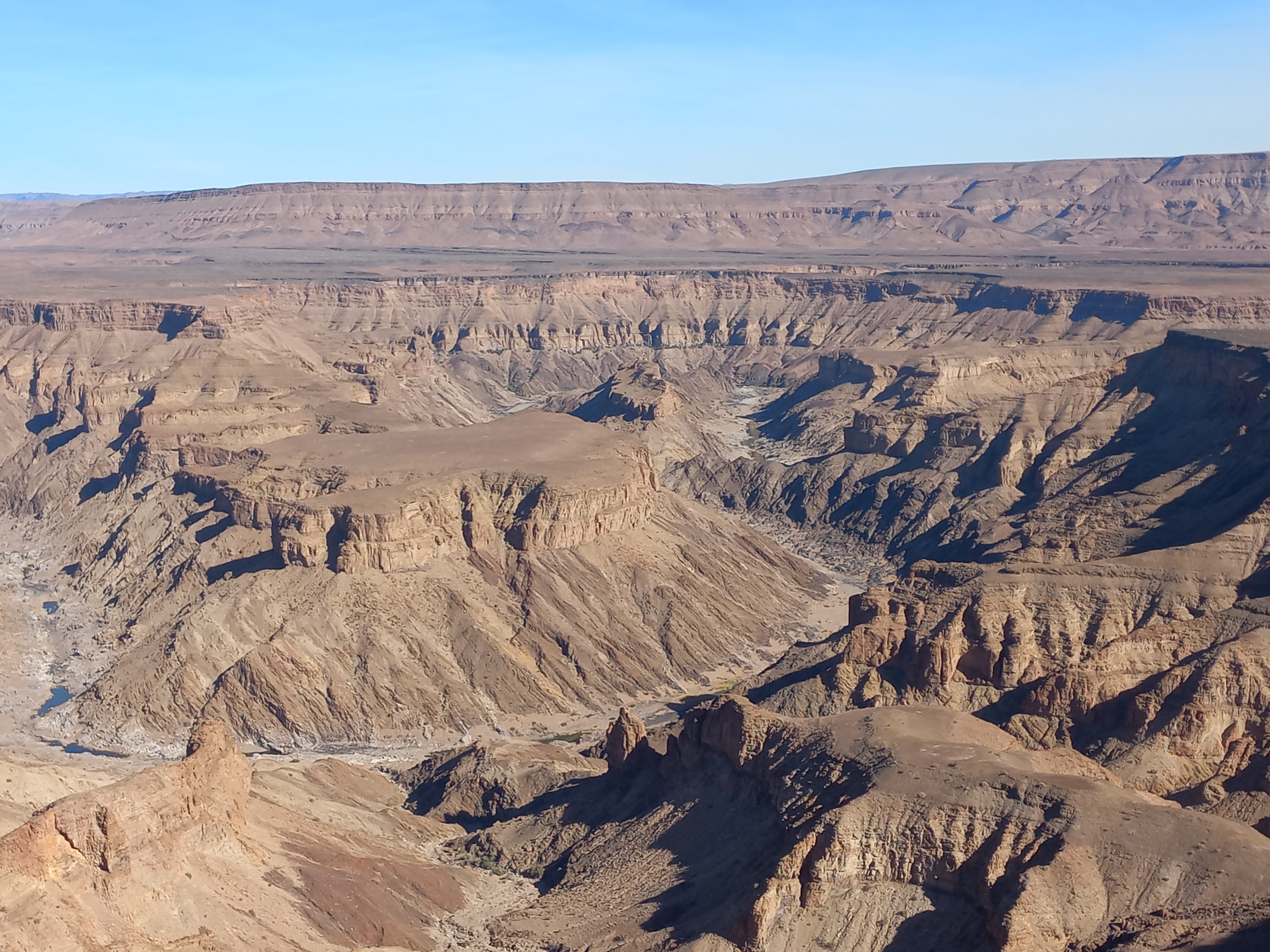
The Fish River canyon, which we were debating about skipping due to the roads, is definitely a must visit. We understand it is only second to the Grand Canyon in America and it's just amazing to see the scale of erosion over the years.
 |
| More tyre replacements needed, this time in Mariental |
It's also hard to visualize the scale of the ancient river systems, but when you consider a super river larger than the Amazon once flowed through Namibia and Botswana, you can begin to understand how a canyon this large could be carved out.
 |
| Spending a night under a working windmill |
There are these river bends and erosion carvings we saw on our way to Tsabong in Botswana where today it's just a desert. It is possible the same super river that flowed through this section of Namibia also went through Tsabong and to the Orange river.
 |
| The Fish River canyon only second to the Grand Canyon in size. |
The last stop in Namibia was Ais-Ais, a peculiar destination based around hot springs along the Fish River canyon about an hour from the South African border. Our thinking was any sort of oasis in this desert would harbor a healthy collection of birds including endemics and so we pulled in for a night.
 |
The river flows a few times a year leaving behind pools of water.
|
The camp itself is impressive but with up to a 100 camp sites our suspicion was this to be a local hangout for weekends from nearby towns including the close by diamond mines. The expected birds numbers weren't there but it was our last night in Namibia before heading for the South African border.
 |
| Canyon view |
It has taken us nearly a month to cover Namibia and it has been a tough and interesting adventure. The diversity of this amazing country is captured between the river based Caprivi Strip (now Zambezi) home to large African mammals, the arid Etosha Pan with the big five and the Namib desert where life on the desert clings on by harvesting the sea mist as moisture.
 |
| Church of the Rock in Lüderitz |
The distances are vast and the roads require your full attention, particularly the gravel roads where the surface can change without a warning. There are also truly remote and inhospitable corners to this country such at the Skelton Coast and parts of Damara land where caution is required before venturing and not advisable for solo travelers.
 |
Delicious fish potjie in Lüderitz
|
The facilities offered by the Namibian Wildlife Services is amazing with well run campsites available at all major attractions including power and running water. We plan to be back someday in Namibia in the dry season to check out Etosha and the horse shoe lagoon which should be at its best.
 |
Fish river canyon views
|
The South African - Namibia border as expected was the easiest of border crossings and a welcome relief after dealing with chaotic East African borders over the last decade.
 |
| Hotel in Swakopmund |
The Tanzania - Zambia border crossing in 2010 took more than 24 hours including us sleeping the night at the border in no mans land. Even the Malawi - Zambia border, a seemingly straight forward task given we were residents of Malawi would take over 2 hours at best.
 |
Endless vistas in Namibia
|
One of the game changes has been digital money which means one no longer has to deal with the money dealers at the border. While digitizing has it's advantages, nothing worse than watching a border official trying to complete an application with one finger typing.
 |
| Gravel roads criss cross Namibia |
Also in both Botswana and South Africa, you are spared the 3rd party insurance leg which usually requires dealing with an 'insurance broker' who insists on being paid in local currency which brings the money dealer in to the transaction.
 |
| Camping in the middle of Namibia |


.jpg)


No comments:
Post a Comment